-
 +855 010 333 879
 - CONTACT US
MYANMAR TRAVEL GUIDE
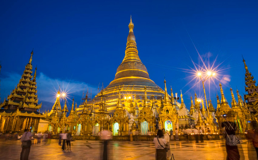
Myanmar (formerly Burma), is a Southeast Asian nation of more than 100 ethnic groups, bordering India, Bangladesh, China, Laos and Thailand. Yangon (formerly Rangoon), the country's largest city, is home to bustling markets, numerous parks and lakes, and the towering, gilded Shwedagon Pagoda, which contains Buddhist relics and dates to the 6th century.
Where to go in Myanmar?
Yangon (formerly Rangoon) is the largest city in Myanmar (formerly Burma). A mix of colonial architecture, modern high-rises and gilded Buddhist pagodas define its skyline. Its famed Shwedagon Paya, a huge, shimmering pagoda complex, draws thousands of pilgrims annually. The city's other notable religious sites include the Botataung and Sule pagodas, both housing Buddhist relics.
The city's green spaces include People’s Park, with fountains and flower gardens, and Kandawgyi Lake, with a replica of a royal barge, waterside cafes and adjacent zoo. The National Museum presents exhibits on Burmese art and culture. The covered market of Bogyoke Aung San is packed with stalls selling traditional lacquerware, antiques, wood carvings and textiles (including the sarong like longyi still worn by many Burmese). The Circular Railway, a commuter train departing from the landmark Yangon Central Station, provides views of a variety of urban and rural landscapes.
Bagan is an ancient city in central Myanmar (formerly Burma), southwest of Mandalay. Standing on the eastern banks of the Ayeyarwady River, it’s known for the Bagan Archaeological Area, where more than 2,000 Buddhist monuments tower over green plains. Holy sites around Old Bagan include ornate Ananda Temple, built in 1091 and topped with a golden stupa. Nearby is the vast 12th-century Dhammayangyi Temple. Also in Old Bagan lie intricately carved Thatbyinnyu, one of the city’s tallest temples, and the huge Hindi temple Nathlaung Kyaung. The riverside Bagan Archaeological Museum exhibits sacred artifacts. Shwezigon Pagoda, also set along the meandering Ayeyarwady River, is a gilded temple dating back to the 11th century. Between the museum and the pagoda, Htilominlo Temple rises dramatically above the trees, while red-stone Sulamani Temple contains painted Buddha statues. New Bagan and Nyaung-U are modern settlements close to the monuments. Southeast of Bagan, Mt. Popa National Park is home to an extinct volcano.
Mandalay
is a city and former royal capital in northern Myanmar (formerly Burma) on the Irrawaddy River. In its center is the restored Mandalay Palace from the Konbaung Dynasty, surrounded by a moat. Mandalay Hill provides views of the city from its summit, which is reached by covered stairway. At its foot, the Kuthodaw Pagoda houses hundreds of Buddhist-scripture-inscribed marble slabs.
Shwenandaw Monastery
another Buddhist holy place at the foot of Mandalay Hill, is covered in teak carvings. The Mahamuni temple, to the southwest, is home to a revered gold-leaf Buddha statue. Amarapura, a township on Mandalay's southern outskirts, is best known for the teakwood U Bein Bridge stretching across Taungthaman Lake. The rural landscape around the small town of Inwa, also to the south, contains ruins and stupas (spherelike Buddhist structures). Across the Irrawaddy, the Sagaing hills are studded with pagodas and offer views of the surrounding valley.
Inle Lake
is a freshwater lake located in the Nyaungshwe Township of Taunggyi District of Shan State, part of Shan Hills in Myanmar. It is the second largest lake in Myanmar with an estimated surface area of 44.9 square miles, and one of the highest at an elevation of 2,900 feet. During the dry season, the average water depth is 7 feet, with the deepest point being 12 feet, but during the rainy season this can increase by 5 feet. The watershed area for the lake lies to a large extent to the north and west of the lake. The lake drains through the Nam Pilu or Balu Chaung on its southern end. There is a hot spring on its northwestern shore. Although the lake is not large, it contains a number of endemic species. Over twenty species of snails and nine species of fish are found nowhere else in the world. Some of these, like the silver-blue scaleless Sawbwa barb, the crossbanded dwarf danio, and the Lake Inle danio, are of minor commercial importance for the aquarium trade. It hosts approximately 20,000 brown and black head migratory seagulls in November, December and January. In June 2015, it becomes the Myanmar's first designated place of World Network of Biosphere Reserves.
Bago
formerly known as Hanthawaddy, is a city and the capital of the Bago Region in Burma. It is located 75 Kilometers north-east of Yangon.
Kengtung
is a town in Shan State, Burma. It is the principal town of Kengtung Township. Kengtung is located on the National Highway 4 and at the AH2 and AH3 of the Asian Highway. The city is served by Kengtung Airport and it is home to the Kyaingtong Degree College. Formerly located at the crossroads of the trade between China and Siam, Kengtung lost its importance owing to the international isolation of the military-ruled Burmese state.
Inwa or Ava
located in Mandalay Region, Burma, is an ancient imperial capital of successive Burmese kingdoms from the 14th to 19th centuries. Throughout history, it was sacked and rebuilt numerous times. The capital city was finally abandoned after it was completely destroyed by a series of major earthquakes in March 1839. Though only a few traces of its former grandeur remain today, the former capital.
Thandwe
is a town and major seaport in Rakhine State, the westernmost part of Myanmar. Thandwe is very ancient, and is said to have been at one time the capital of Rakhine State, then called Arakan. The district has an area of 3,784 square miles. The country is mountainous, the Arakan Mountains sending out spurs which reach the coast. Some of the peaks in the north attain 4,000 and more ft. The streams are only mountain torrents to within a few miles of the coast; the mouth of the Khwa forms a good anchorage for vessels of from 9 to 10 ft. draught. The rocks in the Arakan Range and its spurs are metamorphic, and comprise clay, slates, ironstone and indurated sandstone; towards the south, ironstone, trap and rocks of basaltic character are common; veins of steatite and white fibrous quartz are also found. Between 1961 and 1990, the mean annual rainfall was 5,323 millimetres. Except a few acres of tobacco, all the cultivation is rice.
Taunggyi
is the capital of Shan State, Myanmar. Taunggyi has an estimated population of 380,665 as of 2014, making it the fifth largest city in Myanmar, and is at an elevation of 4,712 feet above sea level. The name Taunggyi means "huge mountain" in the Burmese language, and is named after the ridge on the east of the city, part of the Shan Hills system, whose prominent high point is called Taung-chun or "The Spur." Locally this spur is popularly known as Phaya Taung. The ridge has a more prominent and more popular feature known as Chauk Talone, meaning the Craigs. Recently there has been a flood of Chinese immigrants. Taunggyi lies within the Myelat region of Shan State.
Myitkyina
is the capital city of Kachin State in Myanmar, located 1,480 kilometers from Yangon, and 785 kilometers from Mandalay. In Burmese it means "near the big river", and Myitkyina is on the west bank of the Ayeyarwady River, just below 40 kilometers from Myit-son of its two headstreams. It is the northernmost river port and railway terminus in Myanmar. The city is served by Myitkyina Airport.
Myeik
is a city in Tanintharyi Region in Myanmar, located in the extreme south of the country on the coast of an island on the Andaman Sea. As of 2010 the estimated population was over 209,000. The area inland from the city is a major smuggling corridor into Thailand. The Singkhon Pass, also known as the Maw-daung Pass, has an international cross-border checkpoint.
Kalaw is a hill town in the Shan State of Burma. It is located in Kalaw Township in Taunggyi District.
Mrauk U
is an archaeologically important town in northern Rakhine State, Myanmar. It is also the capital of Mrauk-U Township, a sub region of the Sittwe District. It was the capital of Mrauk U Kingdom, the most important and powerful Rakhine kingdom, from 1430 to 1785.
Sittwe
is the capital of Rakhine State, Myanmar. Sittwe, pronounced site-tway in the Rakhine language, is located on an estuarial island created at the confluence of the Kaladan, Mayu, and Lay Mro rivers emptying into the Bay of Bengal. The city has 181,000 inhabitants. It is the administrative seat of Sittwe Township and Sittwe District.
Putao
is the northernmost town of Kachin State, Myanmar. It is the principal town in Putao Township. It can only be reached by road during summer but is accessible year round by air if there are sufficient tourist groups to justify a plane. The area around Putao is famous for the variety of endemic birds and rare orchids, which grow naturally. Many orchid lovers are especially attracted by the so-called "Black Orchid" that can be found in the mountains east and west of Putao. Hkakabo Razi and other snow-capped mountains are visible from Putao. Putao attracts also enthusiasts, hiking to Hkakabo Razi base camp, located close to Tahaundam.
Mogok
is a city in the Pyin Oo Lwin District of the Mandalay Region of Myanmar, located 200 km north of Mandalay and 148 km north-east of Shwebo. Mogok was in Shan State and after British, the town was put in Mandalay Region along with Pyin Oo Lwin.
Lashio
is the largest town in northern Shan State, Myanmar, about 200 kilometres north-east of Mandalay. It is situated on a low mountain spur overlooking the valley of the Nam Yao river. Loi Leng, the highest mountain of the Shan Hills, is located 45 km to the south-east of Lashio. Lashio is the administrative center of Lashio Township and Lashio District; before April 2010, it was also the administrative center of Shan State. The population grew from approximately 5000 in 1960 to 88,590 in 1983. It is currently estimated at approximately 130,000. The population is made up of mostly Shan, Chinese and Burmans.
Pyin Oo Lwin or Pyin U Lwin
formerly and colloquially referred to as Maymyo, is a scenic hill town in Mandalay Division, Myanmar, located in the Shan Highland, some 67 kilometers east of Mandalay, and at an altitude of 1,070 meters. The town was estimated to have a population of around 255,000 in 2014. Many of the bungalows and villas that the British built during their rule are now occupied by rich locals. Pyin Oo Lwin has 5 names and all names are well-known. Pyin Oo Lwin May myo Taung Lay Khar Taung Sa Kan and the most well-known name, Pan Myo Taw.
Pindaya
is a town in the Shan State of Burma. It is located in the west of the state in Pindaya Township in Taunggyi District. Mainly famous for its limestone caves called Pindaya Caves where thousands of Buddha images have been consecrated for worship over the centuries, it is also one of the towns that host an itinerant market every fifth day.
Dawei
is a city in south-eastern Myanmar and capital of Tanintharyi Region, formerly Tenasserim Division, about 614.3 km south of Yangon on the north bank of the Dawei River. Population, 139,900. It is at 14.09°N 98.20°E. Dawei is a port at the head of the Dawei River estuary, 30 km. from the Andaman Sea. As a result, the city is prone to flooding during the monsoon season. "Dawei" is also the name of one of Myanmar's 135 ethnic minorities.
Mawlamyine
formerly Moulmein, is the fourth largest city of Burma, 300 km south east of Yangon and 70 km south of Thaton, at the mouth of Thanlwin River. The city of 325,927 is the capital and largest city of Mon State, Myanmar and is the main trading center and seaport in south eastern Burma.
Ngwesaung
is a beach resort located 48 km west of Pathein, Ayeyarwady Region, Myanmar. The beach is 5 hours' drive away from the principal city of Yangon, and an airport is in the works. Opened in March 2000, Ngwe Saung is newer than nearby and more popular Chaungtha Beach, and is designed to attract people with larger holiday budgets.
Thanlyin
is a major port city of Burma, located across Bago River from the city of Yangon. Thanlyin Township comprises 17 quarters and 28 village tracts. It is home to the largest port in the country, Thilawa port.
Pathein
formerly called Bassein, is a port city with a 2004 population estimated at 315,600, and the capital of the Ayeyarwady Region, Burma. It lies on the Pathein River, which is a western branch of the Irrawaddy River. Pathein is the fourth largest city of Burma, situated 190 kilometres west of Yangon. It is located within the Pathein Township of Pathein District and is also the seat of all. Although once part of the Mon kingdom, Pathein has few ethnic Mon residents today. The majority are of Bamar, Burmese Indians, Karen ethnicity. There are, however, notable minoritiy Rakhine.
Mong La or Mongla
also known as Little Mong La or Xiaomengla to distinguish from neighboring Chinese Mengla County, is the administrative seat of Mong La Township in Shan State, Burma. Mongla is located opposite Dalou, a Chinese border town in Yunnan Province, and approximately 258 kilometres from Mae Sai, a border town of Thailand, and approximately 80 kilometres north-east of Kengtung. Although technically the town is in Myanmar, electricity, telecommunications, infrastructure works, as well as imports and exports are dependent on China. The main currency used in Mong La is the Chinese yuan.
Monywa
is a city in Sagaing Region, Myanmar, located 136 km north-west of Mandalay on the eastern bank of the River Chindwin.
Amarapura is a former capital of Myanmar, and now a township of Mandalay. Amarapura is bounded by the Irrawaddy river in the west, Chanmyathazi township in the north, and the ancient capital site of Ava in the south. It was the capital of Myanmar twice during the Konbaung period before finally being supplanted by Mandalay 11 km north in 1859. It is historically referred to as Taungmyo in relation to Mandalay. Amarapura today is part of Mandalay, as a result of urban sprawl. The township is known today for its traditional silk and cotton weaving, and bronze casting. It is a popular tourist day-trip destination from Mandalay.
Nyaungshwe Township
is a township of Taunggyi District in the Shan State of Myanmar. The principal town is Nyaungshwe. Inle Lake, a popular tourist site and an inland fresh water lake, is in the south of Nyaungshwe Town. Part of Inlay Lake Wetland Sanctuary lies in Nyaungshwe, Pinlaung and Pekon Township.
Mingun
is a town in Sagaing Region, north-west Myanmar, located 11 km up the Ayeyarwady River on the west bank from Mandalay. Its main attraction is the ruined Mingun Pahtodawgyi.
Chaungtha
is a village and beach resort located in Ayeyarwady Region, Myanmar. Chaungtha Beach, as it is more commonly known, is about 5 hours' drive away from Yangon, and is a popular resort with Yangonites from October to April. As it is relatively more affordable than the nearby Ngwesaung and Ngapali beaches, Chaungtha is also more crowded and less cleanly than the two more expensive and better maintained beaches.
Hsipaw
is the principal town of Hsipaw Township in Shan State, Myanmar on the riverbank of DuthawadiRiver. It is 200 km north-east of Mandalay.
Hpa-An
is the capital of Karen State, Myanmar. Hpa-An is the largest and most populated city in Karen State and it population estimates vary widely as no census has been taken in Myanmar since 1983, and the 2014 census has not yet released the populations of cities. The population as of the 2014 census is 421,575. Most of the people are Karen ethnic.
Pyay
is principal town of Pyay Township in the Bago Region in Myanmar. Pyay is located on the Irrawaddy River and is 260 km north-west of Yangon. The British Irrawaddy Flotilla Company established the current town in the late 19th century on the Irrawaddy as a transshipment point for cargo between Upper and Lower Burma. The district of Pyay encompasses the valley of the Irrawaddy, located between Thayetmyo, Hinthada and Tharrawaddy districts. Along the western side of Pyay District are the Arakan Mountains and along the eastern side are the Pegu Range. Pyay District's main towns are Pyay, Shwedaung, and Paungde.
Myawaddy
is a town in south-eastern Myanmar in Kayin State close to the border with Thailand. Separated from the Thai border town of Mae Sot by the Moei River, the town is most important trading point between Myanmar and Thailand. On 6 August 2010, a bomb exploded in the car park of a crowded market in Myawaddy, killing two men and seriously injuring four others.
Loikaw
is the capital of Kayah State in Myanmar. It is located in the Karen Hills area, near the State's northern tip, just above an embayment on the Pilu River. The inhabitants are mostly Kayah. Myanmar's largest hydropower plant built is located about 20 km east of Loikaw at Lawpita Falls.
Nyaung-U
is the administrative town of Nyaung-U Township of Nyaung-U District in the Mandalay Region of central Myanmar. It lies on the eastern bank of Ayeyarwaddy River. It is just 4 kilometers away from old Bagan, a popular tourist attraction. The Shwezigon Pagoda is located there. The other popular places in and around Nyaung-U were Htilominlo Pagoda Gubyaukgyi Pagoda Ahlodawpyae Pagoda and Hgnet Pyit Taung Hill It is the home of Nyaung U Airport. It can be reached by air, by railway, by bus and by boat. The 8.10 inches rainfall of 19 Oct 2011 was the record breaking one for past 47 years. The previous record was 5.67 inches of 9 Oct 1989.
Sagaing
is the capital of Sagaing Region in Myanmar. Located on the Ayeyarwady River, 20 km to the south-west of Mandalay on the opposite bank of the river, Sagaing with numerous Buddhist monasteries is an important religious and monastic center. The pagodas and monasteries crowd the numerous hills along the ridge running parallel to the river. The central pagoda, Soon U Ponya Shin Pagoda, is connected by a set of covered staircases that run up the 240 m hill. Sagaing was the capital of Sagaing Kingdom, one of the minor kingdoms that rose up after the fall of Pagan dynasty, where one of Thihathu's sons, Athinkhaya, established himself. During the Ava period, the city was the common fief of the crown prince or senior princes. The city briefly became the royal capital between 1760 and 1763 in the reign of King Naungdawgyi. On August 8, 1988, Sagaing was the site of demonstrations which were concluded by a massacre in which around 300 civilians were killed. Today, with about 70,000 inhabitants, the city is part of Mandalay built-up area with more than 1,022,000 inhabitants estimated in 2011. The city is a frequent tourist destination of day trippers.
Ngapali Beach
is famous for its natural and unspotted beauty up to this day. The beach stretches about 3 km with soft white sand fringed by coconut palms.
Lenya National Park
is a national park located in the Tenasserim Hills, Burma in the border area with Thailand, limiting with the Namtok Huai Yang National Park. The park consists of 176,638 hectares of lowland tropical forest. The main purpose of the national park is the maintenance of natural resources. The demarcation is in course. It is governed by the Burma Forest Department and the level of protection is partial, for logging and forest plantations are allowed. The altitudes within the park range from 10 to 855 m. The endangered Gurney's pitta, endemic to Thailand and Myanmar, is found within the park.
Kawthaung Township
is a township of Kawthaung District in the Taninthayi Division of Myanmar. The principal town is Kawthaung.
Heho is a small town in Kalaw Township, Taunggyi District, Shan State of Myanmar. It is the primary air gateway to tourist areas such as Inle Lake. Heho is connected by NH4 to Sakangyi and Taunggyi, the capital of the Shan State in the east. A dirt road northwest from Heho leads to the old silver-lead mines of Maw Son.
Muse
is the capital town of Muse Township also spelled as Mu Se Township in northern Shan State, Myanmar. It is situated on the Shweli River, and is connected by a bridge and road to Ruili in Yunnan Province, China.
Taungoo
is a District level city in the Bago Region of Myanmar, 220 km from Yangon, towards the north-eastern end of the division, with mountain ranges to the east and west. The main industry is in forestry products, with teak and other hardwoods extracted from the mountains. The city is known for its areca palms, to the extent that a Burmese proverb for unexpected good fortune is equated to a "betel lover winning a trip to Taungoo". The city is famous in Burmese history for the Taungoo Dynasty which ruled the country for over 200 years between the 16th and 18th centuries. Taungoo was the capital of Burma in 1510–1539 and 1551–1552. Kaytumadi new city is the central command of the southern command division region of Armed Forces Hanthawaddy United Football Club is based in Taungoo.
Kyaukme
is a town in northern Shan State of Burma. It is situated on the Mandalay - Lashio road, after Pyin Oo Lwin and Nawnghkio, and before Hsipaw, on what is now the Mandalay - Muse road, part of the Asian Highway route 14. It is also connected to Momeik in the Shweli River valley and Mogok with its ruby mines. Kyaukme can be reached by train on the Mandalay-Lashio railway line.
Hlawga National Park is a national park located in Mingaladon, Yangon Division, Myanmar, 22 miles north of Yangon. The 1540-acre park includes an 818-acre wildlife park, a 62-acre mini-zoo and a 660-acre buffer zone. First established as an environmental education center in 1982, the national park is a popular day-trip destination with Yangonites and eco-tourists.
Tachileik, is a border town in the Shan State of eastern Myanmar. It is the administrative seat of Tachileik Township and Tachileik District and most populated city in eastern Shan State with 51,553 residents per 2014 census count, ahead of Kengtung, but only 4th statewide.